


A dangerous bomb cyclone is bringing massive snowstorms, freezing rain, and arctic cold across the United States, threatening to ruin post-holiday travel plans for millions of Americans through the beginning of 2026.
Bomb Cyclone Brings Blizzard Conditions to US
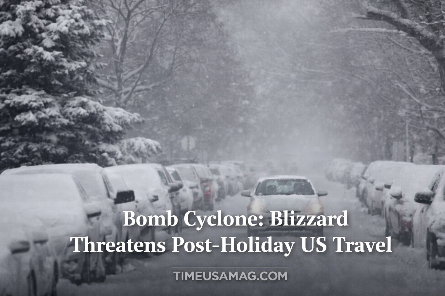
A powerful winter storm system is rapidly intensifying into a bomb cyclone, creating dangerous travel conditions across large parts of the United States from December 28 through December 30, 2025.
The storm is bringing a deadly combination of:
- Heavy snow (up to 2 feet in some areas)
- Strong winds (gusts up to 60 mph)
- Freezing rain creating icy roads
- Whiteout conditions with zero visibility
- Arctic cold plunging temperatures into the teens
Post-holiday travelers heading home after Christmas are facing some of the worst winter weather of the season so far.
What Is a Bomb Cyclone?
Many people are asking: “What is a bomb cyclone?“ It sounds scary, and it actually is a serious weather event!
A bomb cyclone refers to the rapid strengthening of a storm system. According to the National Oceanic and Atmospheric Administration (NOAA), it happens when:
Cold, dry air meets warm, moist air: These two air masses collide violently
Rapid intensification occurs: The storm strengthens very quickly (at least 24 millibars in 24 hours)
Hurricane-like power develops: Though it’s not a hurricane, the storm can have similar intensity
Winter hurricane comparison: Some meteorologists call it a “winter hurricane” because of its power
The term “bomb” refers to how explosively fast the storm intensifies – like a bomb going off in the atmosphere!
Blizzard Warnings for Midwest States
Blizzard warnings are in effect across the Upper Midwest, affecting millions of people in multiple states.
States under blizzard warning:
- Iowa
- Michigan
- Minnesota
- North Dakota
- Wisconsin
What “blizzard warning” means:
Heavy snow: Falling continuously for hours
Strong winds: Sustained winds of 35+ mph with higher gusts
Near-zero visibility: Whiteout conditions where you can’t see anything
Life-threatening conditions: Extremely dangerous to be outside or driving
Duration: The storm will intensify between Sunday and Monday, with snow becoming heaviest Sunday evening
This isn’t just a regular snowstorm – it’s a potentially deadly weather event!
Up to 2 Feet of Snow Expected
Some areas could see absolutely massive snow accumulation from this bomb cyclone.
Snowfall predictions:
Great Lakes shores: Up to 2 feet (24 inches) of snow possible
Most of Upper Midwest: 12-18 inches expected
Some areas: As little as 6 inches but still with dangerous conditions
Lake-effect enhancement: Areas near the Great Lakes will get extra snow
The combination of heavy snow PLUS strong winds creates the most dangerous situation – you can’t see anything, and getting stuck means potential hypothermia.
Dangerous Wind Gusts Up to 60 MPH
The snow alone would be bad enough, but the bomb cyclone is also bringing incredibly strong winds.
Wind forecast:
Peak gusts: Up to 60 mph in some areas
Sustained winds: 35-45 mph for hours
Whiteout conditions: Wind blowing snow creates zero visibility
Blowing and drifting: Snow will pile up in huge drifts blocking roads
Wind chill danger: Makes temperatures feel 20-30 degrees colder
According to AccuWeather Senior Meteorologist Bill Deger:
“Such strong winds can also lead to power outages, downed tree limbs and airborne holiday decorations.”
Imagine your neighbor’s Christmas decorations becoming dangerous projectiles!
Massive Flight Delays at Major Airports
The bomb cyclone is causing travel chaos at airports across the United States.
Flight delay statistics as of Sunday midday:
Chicago O’Hare International Airport: About 25% of flights delayed
Minneapolis-St. Paul International Airport: About 25% of flights delayed
Nationwide: Close to 4,000 flights into and out of the US delayed
Cancellations: Numbers climbing as conditions worsen
Affected airports also include:
- Detroit Metropolitan Airport
- Milwaukee Mitchell International
- Des Moines International
- Madison Airport
If you’re traveling through the Midwest, expect major delays or cancellations!
Power Outages Expected Across Midwest
The combination of heavy snow and strong winds creates perfect conditions for widespread power outages.
Why power outages will happen:
Heavy snow on power lines: Weight can snap lines
Strong winds: 60 mph gusts knock down power poles
Tree branches: Ice and wind cause branches to fall on lines
Equipment failure: Extreme cold affects electrical equipment
Difficult repairs: Blizzard conditions prevent quick fixes
Areas most at risk:
- Rural communities in the Upper Midwest
- Great Lakes coastal areas
- Heavily wooded regions
Make sure your phone is charged and you have flashlights, batteries, and emergency supplies ready!
Freezing Rain Creates Icy Roads in New England
While the Midwest battles snow, New England faces a different but equally dangerous threat: freezing rain.
What’s happening in New England:
Sunday forecast: Freezing rain throughout the day
Ice accumulation: Coating roads, sidewalks, power lines
Extremely slippery conditions: Even small amounts of ice make driving treacherous
Black ice danger: Invisible ice patches cause sudden loss of control
States affected:
- Maine
- New Hampshire
- Vermont
- Massachusetts
- Connecticut
- Rhode Island
Freezing rain is arguably MORE dangerous than snow because it’s harder to see and creates instant slick conditions.
Arctic Cold Blast Hits Central and Southern States
The bomb cyclone is pushing a massive wave of arctic air southward, bringing shocking temperature drops to areas that just had record warmth.
Temperature forecast:
Sunday afternoon/evening: Arctic blast arrives
Temperature drop: From 60s-70s down to 20s and teens overnight
Record lows possible: Some areas could break cold records
Wind chill: Feels even colder with wind factoring in
States affected:
- Arkansas
- Tennessee
- Mississippi
- Alabama
- Kentucky
- Parts of Texas
- Ohio Valley
According to AccuWeather meteorologist Bill Deger:
“A stretch of record-high temperatures across the Central and Southern United States will end abruptly as a wave of arctic chill rushes in Sunday afternoon and evening.”
People enjoying warm Christmas weather will be shocked by the sudden freeze!
Powerful Thunderstorms Moving East
Before the cold arrives in the South, dangerous thunderstorms will develop along the temperature boundary.
Storm forecast:
Sunday evening: Storms develop in Arkansas and surrounding areas
Monday: Storms move east toward:
- Midwest
- Ohio Valley
- Tennessee Valley
- Coastal Southern states
Storm threats:
- Heavy rain
- Lightning
- Strong winds
- Possible tornadoes (though less likely in winter)
- Flash flooding
After the storms pass, temperatures will plunge, potentially causing rapid icing on roads – extremely dangerous!
Roads Will Ice Over Quickly
One of the most dangerous aspects of this bomb cyclone weather system is how fast conditions will deteriorate.
The icing danger:
Wet roads + plunging temperatures = instant ice
Process:
- Thunderstorms drop rain on roads
- Arctic cold arrives within hours
- Water freezes before it can drain
- Roads become skating rinks
Why this is so dangerous:
- Drivers don’t expect sudden ice
- Roads look wet but are actually frozen
- Black ice is nearly invisible
- Causes multi-vehicle pileups
- Emergency vehicles can’t respond quickly
Most dangerous time: Sunday night through Monday morning as temperatures crash
California Finally Gets Dry Weather
After days of devastating rain and flooding, California is finally catching a break.
West Coast forecast:
Atmospheric river ending: The “firehose” of moisture shuts off Sunday
Drier weather ahead: Much calmer conditions through early week
Cleanup begins: Communities can assess damage and start repairs
What California just experienced:
- Multiple days of heavy rainfall
- Mudslides and evacuations
- Power outages affecting thousands
- Several storm-related deaths
- Flooding in low-lying areas
Snow in mountains: The Rockies and Pacific Northwest will see their snow taper off, though southeastern New Mexico could still see some accumulation Monday
The West gets a much-needed break while the rest of the country faces winter fury.
Travel Safety Tips for Bomb Cyclone Conditions
If you absolutely must travel during this bomb cyclone, follow these critical safety tips:
Before you leave:
Check conditions constantly: Weather changes rapidly Fully charge your phone: You may need to call for help Fill your gas tank: Don’t let it get below half Pack emergency supplies: Blankets, food, water, first aid kit Tell someone your route: So they know where to look if you don’t arrive
While driving:
Slow down significantly: Speed limits are for good conditions Increase following distance: Allow 3x normal stopping distance Avoid sudden movements: Brake and turn gently Turn off cruise control: You need full control If you start sliding: Don’t panic-brake; steer into the skid
If stranded:
Stay with your vehicle: It provides shelter Run engine briefly for heat: But crack window and clear exhaust pipe Stay visible: Tie bright cloth to antenna Don’t overexert: Shoveling snow in cold can cause heart attacks Call for help: Then wait patiently
Should You Cancel Travel Plans?
With this bomb cyclone creating dangerous conditions, should you cancel your travel plans?
Consider canceling if:
✅ You’re driving through blizzard warning areas ✅ Your flight is through Chicago, Minneapolis, or Detroit ✅ Freezing rain is forecast for your route ✅ You’re not experienced driving in winter conditions ✅ Your travel is optional or can be rescheduled
You might be okay if:
✅ You’re flying to/from unaffected areas ✅ Your route avoids the Midwest and New England ✅ You’re traveling after Tuesday when conditions improve ✅ You have 4-wheel drive and winter driving experience ✅ You have flexible plans if delays occur
Remember: No trip is worth your life. If conditions are dangerous, stay home!
When Will the Bomb Cyclone End?
The good news is this bomb cyclone won’t last forever – but it will take a few days to pass.
Timeline:
Sunday, December 28: Storm intensifies; worst conditions begin
Monday, December 29: Peak impacts across Midwest and East; most dangerous day
Tuesday, December 30: Storm begins weakening; conditions gradually improve
Wednesday, December 31 (New Year’s Eve): Much calmer weather returns; cold but clearer
Thursday, January 1, 2026: Mostly clear; safe to travel again
Plan to stay put through Monday if possible. Travel on Tuesday or later will be much safer.
Historical Context: How Bad Is This Bomb Cyclone?
While every bomb cyclone is serious, how does this one compare to historic winter storms?
Notable past bomb cyclones:
January 2018: “Bomb Cyclone Grayson” brought hurricane-force winds and flooding to East Coast
December 2022: Historic bomb cyclone dropped temperatures 50+ degrees in hours; killed dozens
January 1978: “Cleveland Superbomb” killed 70 people and paralyzed the Midwest
This storm (December 2025): Significant but not record-breaking; serious enough to cause deaths and major disruptions
The key is taking it seriously – even a “normal” bomb cyclone can be deadly if you’re unprepared.
Climate Change and Winter Storms
You might wonder: If the Earth is warming, why are we getting such intense winter storms like this bomb cyclone?
The science:
Arctic warming: The Arctic is warming faster than other areas
Jet stream changes: This affects how cold air moves south
More moisture: Warmer air holds more moisture, creating heavier snow
Greater extremes: Climate change makes extreme events more extreme
Not a contradiction: Global warming can mean more intense local winter storms
Bottom line: Climate science predicts both warmer average temperatures AND more extreme weather events – which is exactly what we’re seeing.
Emergency Preparedness Checklist
Is your home ready for this bomb cyclone? Use this checklist:
Power outage preparation:
□ Flashlights with fresh batteries □ Battery-powered or hand-crank radio □ Phone fully charged + backup battery pack □ Candles and matches (use safely!) □ Keep fridge/freezer closed to preserve food
Warmth and safety:
□ Extra blankets and warm clothing □ Space heater (if power stays on) □ Know how to safely use fireplace □ Carbon monoxide detector working □ Fire extinguisher accessible
Food and water:
□ 3-day supply of non-perishable food □ Manual can opener □ Bottled water (1 gallon per person per day) □ Medications filled and ready
Outside preparation:
□ Bring outdoor furniture inside □ Secure holiday decorations □ Stock up on ice melt/salt □ Snow shovel accessible □ Full tank of gas in vehicles
Conclusion: Take This Bomb Cyclone Seriously
This bomb cyclone bringing blizzard conditions, freezing rain, and arctic cold across the United States is no joke. With up to 2 feet of snow, wind gusts to 60 mph, and temperatures plunging into the teens, this storm system poses real dangers.
Key takeaways:
Blizzard warnings cover much of the Upper Midwest through Monday
Flight delays are massive at Chicago, Minneapolis, and other major hubs
Freezing rain threatens New England with dangerous ice
Arctic blast will shock the Central and South with sudden cold
Power outages are likely due to heavy snow and strong winds
Travel should be avoided in affected areas through Monday
Conditions improve by Tuesday, with Wednesday looking much better
If you’re in the path of this bomb cyclone, please take precautions seriously. Stock up on supplies, charge your devices, avoid unnecessary travel, and check on elderly neighbors who might need help.
Mother Nature is showing her power this post-holiday weekend. Respect it, prepare for it, and stay safe!
Stay updated: Monitor local weather forecasts constantly as conditions can change rapidly. Follow National Weather Service warnings and advisories for your specific area. Better to be over-prepared than caught off-guard!
Read More :
The Cure Guitarist Perry Bamonte Dead at 65: Band Mourns Loss